Geographical Information System- for food biomass assessment
Małgorzata Kozak
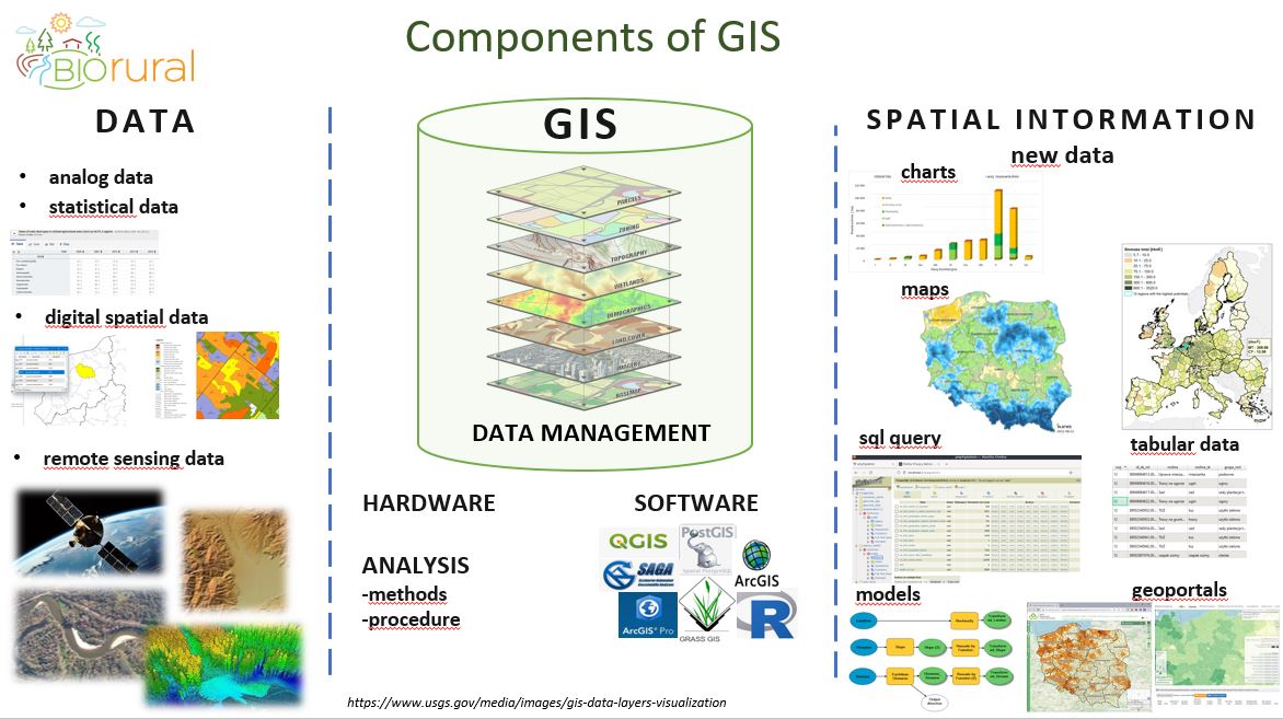
The presentation devoted to data integration in GIS for biomass monitoring. The speaker presents definition of Geographical Information System formulated by ESRI: system that creates, manages, analyses and maps all types of data. It is used in many fields, by many organisations. GIS helps users understand patterns, and relationships in geographical context. The speaker presents the components of GIS. Data is the basic component of GIS and comprise analog, statistical, digital spatial, and remote sensing data, which are integrated into data management systems – spatial information systems enable the compilation of information that is usually grouped on different maps or in different databases. A GIS software program supports the use of a geographic information system, providing the ability to create, store, manage, query, analyze, and visualize geographic data. The GIS software industry encompasses a broad range of commercial products but there is also more and more free software constantly updated and developed by the GIS community. Analyses performed in GIS environment have been used in many research projects presented. A series of spatial data and analytical models were collected and developed to create the “Biomass Estimation System”, which is based on components similar to the GIS components. The presented results in form of maps and geoportals are e.g.: BioBoost Platform presenting technical and theoretical potentials of various types of biomass for NUTS3 units, or Bioeconomy Platform – tool supporting the development of the bioeconomy in Poland and providing access to a set of geoportals. An example on a national scale is the biomass monitoring system created as part of a targeted subsidy. In the case of agricultural biomass, it uses the annually updated database of the Agency for Restructuring and Modernization of Agriculture (ARMA). This database contains information necessary for monitoring and modeling agricultural biomass resources in the field of plant and animal production. The detailed nature of this data made it possible to estimate individual potentials at the farm level, taking into account three production directions: farms with plant production, farms with animal production, mixed farms.
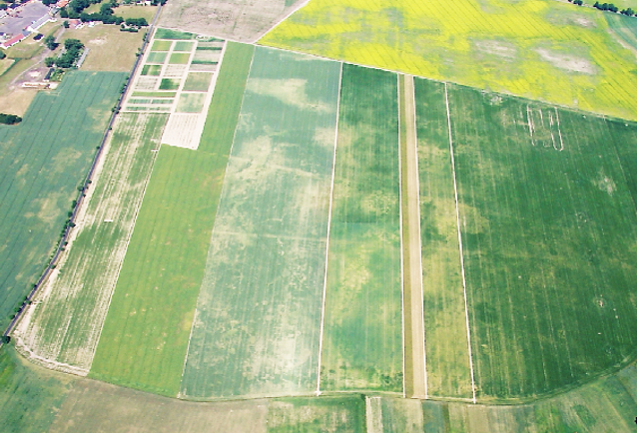
Satellite monitoring for agricultural drought
Anna Jędrejek
The presentation is devoted to Satellite monitoring of agricultural drought, based on sentinel imagery. Sentinel imagery is available free of charge thanks to the Copernicus Programme, a long-term EU observation and monitoring programme, which currently has seven satellites in orbit, offering: (1) and (2) – high resolution land and ocean monitoring; (3) – ocean and global monitoring; (4), (5) and (5P) – atmospheric composition monitoring; (6) sea level monitoring. Twelve more are already approved to launch. Satellite imagery has been used for agricultural application for almost 50 years. It allowed to monitor natural phenomena, such as drought occurrence, crop conditions and identification, but was expensive until now, when Satellite-1 and -2 images are available free of charge. Sentinel-1 and Sentinel-2 high-resolution satellite images allow for permanent monitoring even of a single agricultural field in time and space. Sentinel-2 mission was designed to provide high-resolution optical images for land monitoring, but their availability depends on weather conditions, while Sentinel-1 mission provides high-resolution radar images in all weather conditions. The synergy of these two types of data creates opportunities for Earth observations that have never existed before. The speaker presented how the imagery can be used in practice, based on the conducted research regarding agricultural drought remote sensing in West Pomeranian Voivodeship in Poland, 2021. The study included a comparison of agricultural drought seen from satellite and how farmers estimated their crop losses. When exploring the relationship between farmers’ declarations and the vegetation condition, no cause-and-effect relationship was found. This may be caused by the fact that the vegetation condition depends not only on the soil and weather (drought), but also on a wide range of agrotechnical practices conducted by farmers. The agrotechnics influences the crops’ condition, which is discussed based on the comparison of two neighbouring plots – differences are visible both in the RGB image as well as when comparing the average NDVI values.
Remote sensing for land monitoring
Rafał Pudełko
The presentation focuses on the topic of satellite remote sensing in land monitoring. The speaker presented different types and methods of remote sensing depending on the height of observations conducted: terrestrial machinery, low altitude, aerial, and finally satellite remote sensing. Remote sensing can also be divided based on the mode of measurements into passive and active, the first one based on reflection received from the observed objects, and the second requiring emitting radiation and analysing the way it is reflected by the objects. Another characteristics of remote sensing is resolution offered by different sensors, presented on the example offered by Pleiades, Sentinel, and MODIS, offering resolution of 2 m, 10 m, and 250 m respectively. The first two can be useful for application in precision agriculture. The speaker focused on the possibilities offered by the Sentinel imagery and presented how it can be useful for application in agriculture, e.g. (1) plant development monitoring; (2) drought/ flood/ frost/ hailstorm effect; (3) precision agriculture support; (4) Land use and Land use change mapping, and many others. Remote sensing can be used for developing monitoring and advisory systems, an example of which is FaST platform – an EU supported digital service platform which is a decision support system dedicated for farmers, advisors, administration, policy makers and other interested stakeholders.
RAMAS-Remote Agriculture Monitoring and Advisory System for improvement of agri production and resources optimization
Mario Petkovski
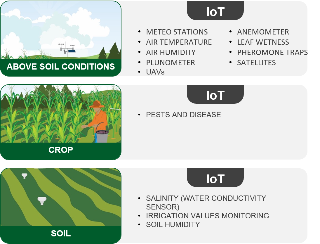
The presentation is devoted to monitoring and advisory systems in agriculture, allowing for production improvement and resources optimisation, based on the example of RAMAS (Remote Agriculture Monitoring and Advisory System) developed by AgFutura Technologies. Digital technologies for agriculture bring about benefits such as efficiency, productivity, sustainability, and traceability. It helps to optimise the use of resources while maximising yields and their quality, to incorporate the robotics and replace difficult human labour with machinery. The speaker presented how the RAMAS system works; it consists of 5 key layers: (1) farm and monitoring layer (installation and configuration of sensors on the field to collect data, supported with remote sensing sources), (2) data center/processing layer (producing information on the crops state on the field); (3) data analysis and reporting layer (producing recommendation for farmers); (4) recommendation adaptation layer (supporting implementation of recommendations); (5) calibration layer (continuous evaluation of reports and processes). The benefits for farmers are as follows: • Continuous expert support and advise • Crop health monitoring • Insight into all agrotechnical operations • Obtaining recommendations for irrigation, pesticides, fertilisation, and other practices to optimise effort and costs

Invention support and commercialization in the field of agriculture and food production of scientists from public research centres on the example of Poland
Piotr Jurga
This presentation is devoted to the topic of commercialization of research and support of invention in the field of agriculture and food production, based on the example of research centres in Poland.
Circularity in the food processing industry - valorisation of various waste streams originating from wine production
Slavcho Aleksovski
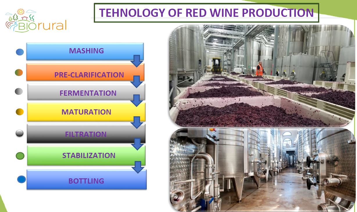
This presentation is devoted to the topic of food circular economy and possibilities of waste streams valorisation from wine production. The speaker discussed the circular economy as opposed to the linear one, which depletes finite resources and pollutes the environment. Circular economy is based on recycling and reusing instead of generating waste streams. The process of wine production from grapes is a very old process. Grapes are rich in sugars, organic acids, vitamins, bioactive compounds and minerals, significant amounts of which are found in peels and seeds. Those are considered waste and as such have not been adequately used till now, usually deposited on landfills in huge amounts each season. The speaker presented the process of wine production and discussed each step, leading to obtaining the product but also large amounts of waste in form of grape pomace, including peels, seeds, and stalks. Grape seeds are rich in oil and polyphenols, grape skins contain antioxidants, while grape stalks can be a source of cellulose, hemicellulose and lignin. This waste can be valorized using new technologies, such as oil extraction, extraction of cellulose and other hydrocarbons, phenols and natural colorants, or bioethanol, biofertiliser, and biochar production. Adoption of such technologies can have both socio-economic and environmental benefits.
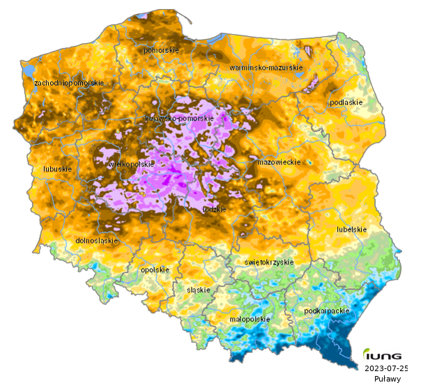
Agriculture Drought Monitoring System (ADMS) in Poland
Katarzyna Żyłowska
The presentation discussed the phenomenon of agricultural drought and the Agricultural Drought Monitoring System. The speaker presented different types of drought: atmospheric, hydrological, agricultural, focusing on the last one and its implications for agriculture. One of them is the loss of yield and therefore loss of farmers’ income. To deal with this problem, the Polish Ministry commissioned development of a drought monitoring system, to keep track of the losses and support farms affected. The Agricultural Drought Monitoring System (ADMS) was developed and implemented by the Institute of Soil Science and Plan Cultivation – State Research Institute in Puławy (IUNG-PIB). The purpose of ADMS is to identify areas where drought losses have occurred in crops included in the “Act on Subsidies for Crop and Livestock Insurance in Poland” (Dz. U No.150, item 1249, 2006, No. 120, item 825). The following crops (or group of crops) are specified: winter cereals, spring cereals, grain maize, silage maize, rape and turnip rape, potato, sugar beet, hops, tobacco, fields grown vegetables, fruit shrubs, fruit crops, strawberries leguminous crops. This Act introduces the definition of agricultural drought as follows: Drought is indicated by damage caused by the occurrence of a climatic water balance below a certain value for various species or groups of cultivated plants and soil categories during any six-decade period from 21 March to 30 September. Climatic water balance (CWB) was defined as difference between precipitation and potential evapotranspiration (ETP) for a six consecutive ten-days period. In the vegetation season 14 monitoring reports are produced. The first report evaluating CWB in the season of ADAMS is presented for the period from 21 March to 20 May, the next and following reports in the year is issued every 10 days. In the second step, based on the CWB map, an exceedance of the CWB drought threshold defined for crops covered by the monitoring system and four classes of soils with different vulnerability to drought are performed, based on this analysis, the map of the area affected by drought is made. The ADMS indicate the area affected by drought based on climatic water balance map and soil categories map. The information is available at LAU-2 level (municipalities). The analyses are updated every 10 days from 20 May to 30 September. The analyses of the ADMS are available for farmers on the web service (https://susza.iung.pulawy.pl/en/), where they can check information on the use of maps or interactive tables at municipality level (LAU-2).

Plant and animal extraction service
Mateusz Galiński
The presentation is devoted to plant and animal extraction services, using ultrasound extraction and selective sorbents. The speaker presented the offer and expertise of the company Creo Plus, and discussed specific case studies where their technology was successfully used. The first case study was shrimp shell extraction. Shrimp shell is a huge amount of waste in seafood industry and has a large untapped potential. The Creo Plus company developed a process of astaxanthin and chitin extraction. The second case study concerned developing an extraction process of valuable substances from plants.
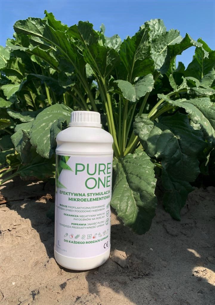
Innovative methods of plant simulation using mineral fertilizers and biostimulants
Anna Ogar
This presentation is devoted to biostimulants and mineral fertilisation of plants. The speaker discussed various regulatory limitation imposed on farmers and climate induced risks they have to face at the same time. The answer to this challenge is making use of innovative technology to improve crops resilience, allowing for limiting the use of plant protection products and fulfilling the targets set by EU regulations. The product focuses on empowering crops, not fighting pathogens. It (1) activates enzymes and metabolic pathways to enhance crop growth and productivity, (2) stimulates natural immunity of crops, (3) mitigates abiotic stresses caused by drought and frost, (4) enhances carbon sequestration through intensifying photosynthetic activity of plants, and biomass accumulation in roots and shoots. Pure Technology has been tested for safety in Poland and abroad. It’s effectiveness has been proven both in laboratory and field trials. The product is said to reduce carbon footprint in agriculture as well. The product is already available on the market. The benefits for farmers and consumers enumerated by the speaker include: (1) Higher crop yields (5-30%) without extra strain on the environment (2) Producing more and better with less (3) Driving productivity of high quality food while increasing the humus content in soil

Use of mobile application for rational fertilizer use by agricultural producers
Beata Jurga
The presentation is devoted to the issue of rational fertilisation based on the example of INTER-NAW application. This application is a free of charge decision support tool, available in desktop and online version. It is in line with the current legal requirements, e.g. the Nitrate programme regulating N-application in Poland. The tool calculates required doses of N-fertilisers based on the nutrient balance, taking into account N-sources such as: manures, other organic fertilisers, biological fixation, soil resources, plant by-product of pre-crop left on the field, and mineral fertilisers, as well as Nitrogen output. The tool is also used to calculate PKMg fertiliser doses based on the balance method. Mineral fertilisers are recommended only as a supplement to nutrients provided from other sources. The speaker presented the structure of the tool, discussed its functionalities, and required data input. The advantages offered by the INTER-NAW tool are as follows: – Balanced fertilisation – Addressing the nutritional requirements of plants – Taking into account availability of nutrients – Importing data from existing systems – Practical implementation of the “Nitrate Programme” – Meeting EU requirements
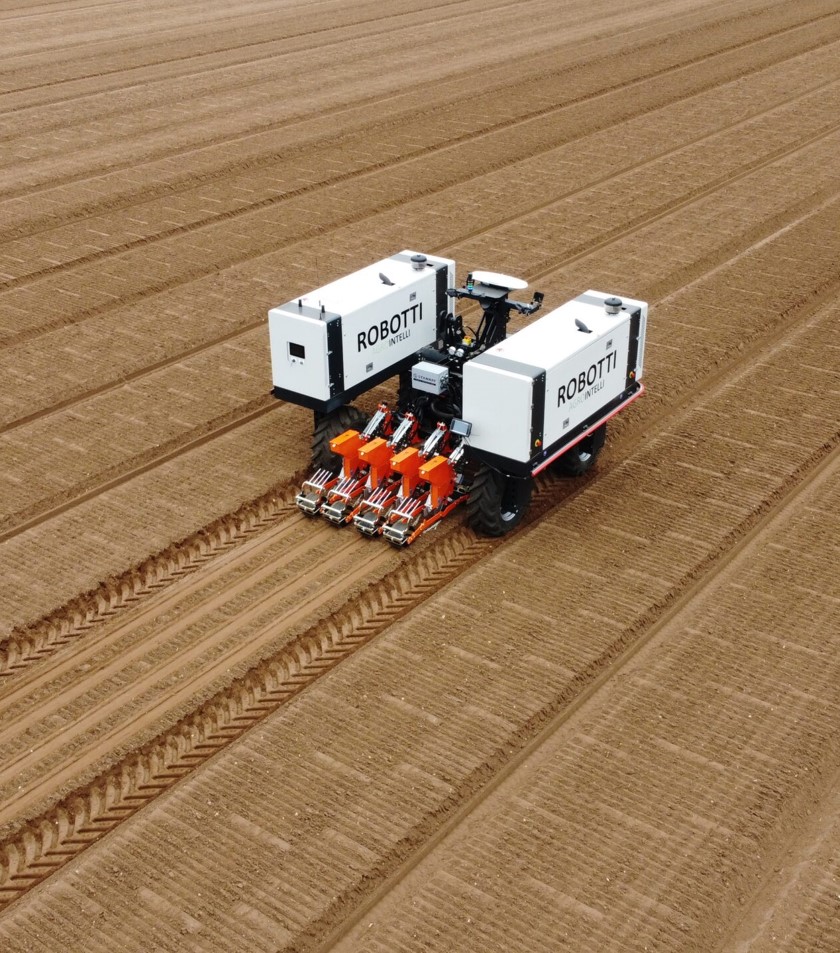
ROBOTTI autonomous field robot in various in field applications
Michał Zabost
The speaker presents Robotti – autonomous farming robot developed by AgroIntelli, which enables transition to sustainable farming by reducing labour cost, while increasing its precision. The success of the machine is based on four pillars: 1) Precision of machinery which is much higher in comparison to human labour; 2) Efficiency – Robotti can work 24/7 (up to 60h of continuous work, depending on the diesel tank capacity); 3) Reliability – the machine is built on high quality components and proven technology; 4) Safety is ensured by safety systems keeping the robot on track and monitoring the surrounding area to react to unforeseen obstacles. The robot is already 24 years old, it has undergone substantial improvements over time. The present design allows for: • Fully autonomous work • Implementation of precision farming • Reduction of soil compaction (weight of 3 tons) • Accurate and precise navigation The robot is driven by standard diesel engine & hydraulics, and is equipped by a standard tractor 3-point hitch. It can work with the equipment existing on the farm. Robotti solves the most common problems of farmers: – Takes over repetitive tedious work – Allows for cost optimisation – Reduces soil compaction and degradation – In line with higher requirements for food safety and its documentation – Starting the season earlier (entering the field) thanks to light weight of the machine – The only agricultural robot compatible with standard implements on the market
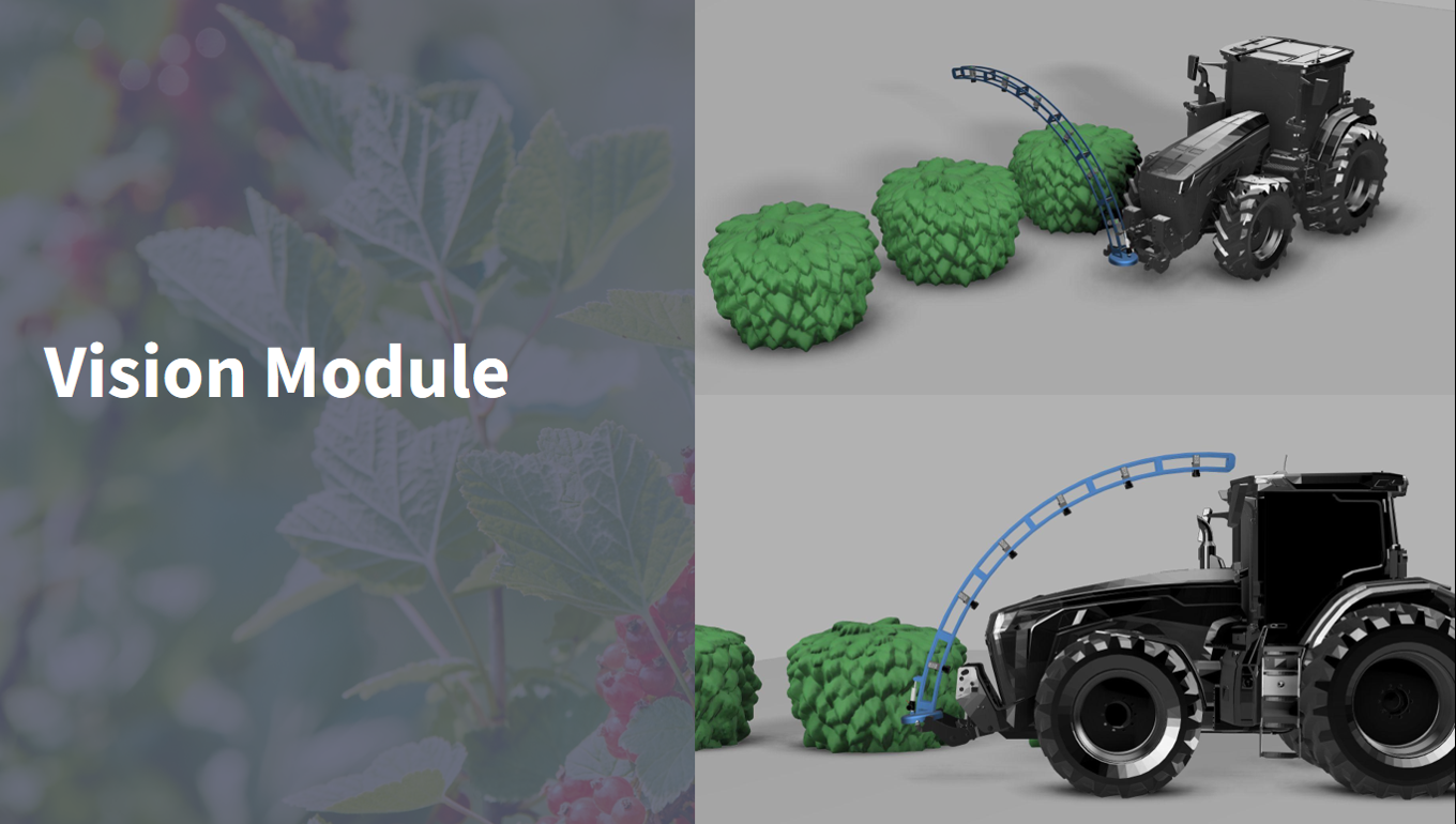
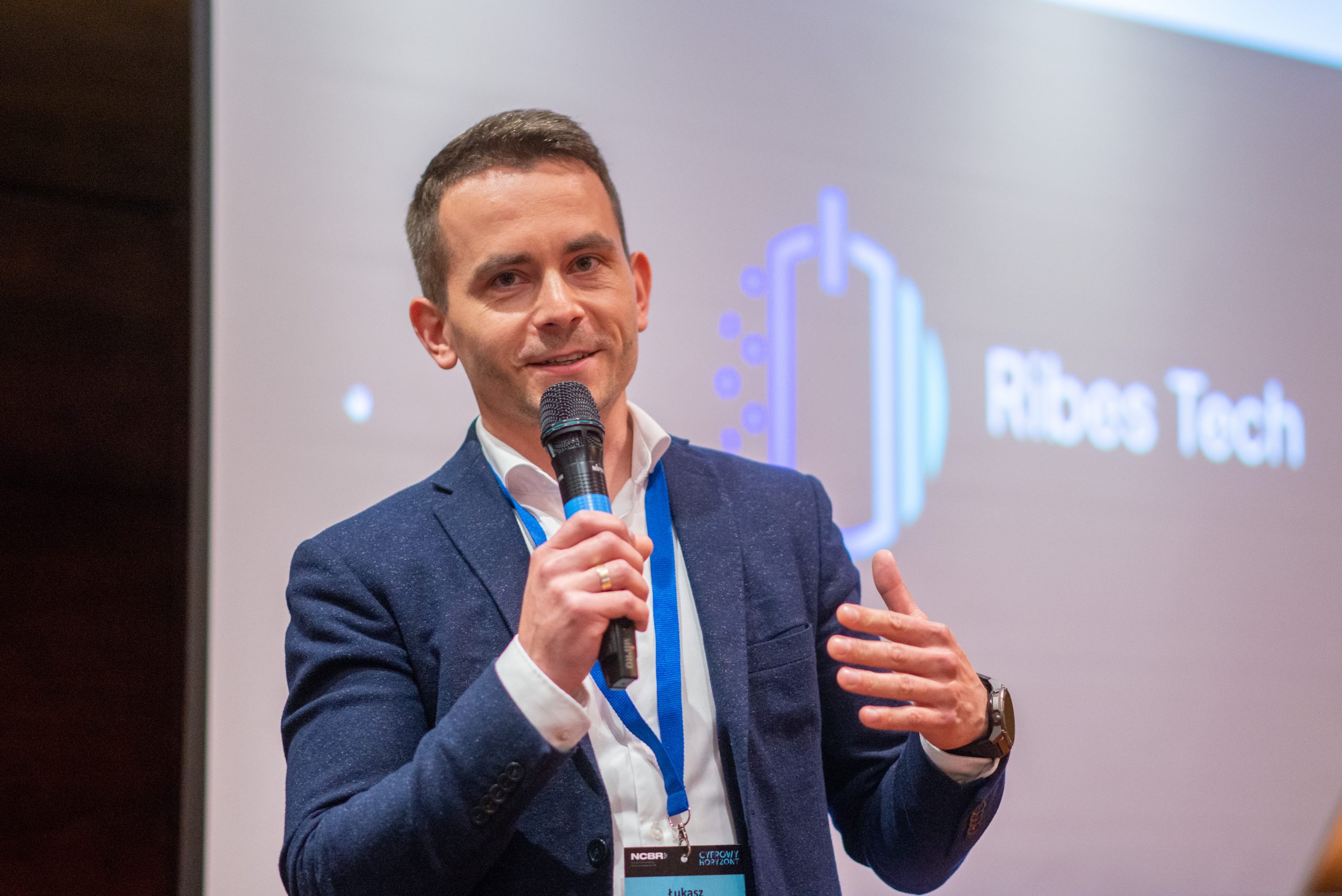
Artificial Intelligence in reducing plant protection chemicals
Łukasz Kopiński
The presentation focuses on the problem of pesticides used in agricultural production and possibilities of reducing them without affecting the yield. Pesticides help to protect agricultural crops against yield losses caused by pests, but they also have detrimental influence on the environment, leading to problems such as destruction of biodiversity, pollution of water bodies, decline in numbers of pollinators. They are also present in the food consumed by people. The problem of pesticides is recognised by the European Union and reflected in the European Green Deal which sets a goal to reduce the use of pesticides by 2030 by 50%. It means new strict regulations and monitoring of PPP but also new possibilities of financial support for innovations in this area. The speaker presents an innovative machinery developed by Ribes Technologies: the autonomous electrically powered platform automatically applying selective pesticides. The prototype of the machine is tested on the currant plantation. Based on plant observation, the machine can recognise infected bushes (with insects and fungi) and apply conditional spraying with PPP. It allows reduction of pesticide use by up to 50%, as well as reduction of costs. Spraying takes place at night, not to affect pollinators on the plantation. Based on own experience, the speaker presented three conclusions, as follows: 1) Technological solutions of agriculture 3.0, 4.0 and 5.0 provide the best support for the development of business models in fruit production. 2) The Green Deal legal regulations are ahead of reality and technological solutions available for agriculture. 3) Technology for agriculture should be co-created with the support of EU funds rather than expected to use ready-made solutions.
Nutrient recycling practices- new opportunities for agriculture -MainstreamBio
Piotr Skowron
The speaker discussed nutrient recycling practices, as well as research projects and policies connected with this subject. He started with defining nutrient recycling and nutrient recycling practices, which allow for recovering nutrients. Nutrient recycling practices are sustainable practices that help reduce waste and pollution while improving soil health. They reduce the use of non-renewable resources and thanks to that can reduce emissions into the environment. The huge demand for food combined with food production needs for nutrients creates a high need for fertilisers. The production and transportation of mineral fertilizers requires consuming large amounts of energy from fossil fuels and in case of e.g. phosphorus – depleting resources of a long-term renewable minerals. Nutrient recycling practices allow for solving those problems and many others. The importance of sustainable nutrient management and recovery is highlighted in the recent European policy. • The Green Deal formulates ambitious targets for sustainable food production, and reduction of nutrient loses by 50% accompanied by 20% reduction in the use of fertilisers is one of them. • The Integrated Nutrient Management Plan aims to ensure sustainable application of nutrients and stimulating markets for recovered nutrients • The Common Agricultural Policy provides a unified policy regarding fertilisation and nutrient management • The EC Circular Economy Action Plan aims at reducing waste, dependence on raw materials as well as GHG emissions. • The Water Framework Directive & Nitrates Directive preventing pollution of groundwater and surface water by nitrates from agricultural sources • Regulation (EU) 2019/1009 harmonizing standards for fertilizing products derived from organic and secondary raw materials • Waste Framework Directive regarding organic waste streams and their possible use for nutrient recovery • Helsinki Convention: on prevention of pollution from agriculture and on nutrient recycling • Baltic Sea Regional Nutrient Recycling Strategy promoting nutrient recycling in a closed loop and reduction of nutrient losses to water and atmosphere, among others The speaker discussed the new kind of RENURE fertilisers derived from livestock manure and its examples. He also presented research projects dealing with the topic of nutrient recycling, which are for instance: • Mainstream BIO – Mainstreaming small-scale bio-based solutions across rural Europe; one of the objectives of which is to establish best practices for improved nutrient recycling. The project collected and described 30 nutrient recycling practices, some examples of which were briefly presented (slurry acidification, Manure & digestate separation). • OrgSafety – introduction of innovative, cheap, and environmentally friendly method of hygenization of organic waste enabling its use in fertilisation • CiNURGi – Circular Nutrients for a Sustainable Baltic Sea Region

Value chains in food systems
Paweł Chmieliński
The presentation provides a definition of food systems and explanation, why it is important to analyse them using a systemic approach, as opposed to sectoral, monofunctional, and fragmented analyses. Food systems are an interesting and valid topic of deliberations in the context of rural and agricultural development, contemporary agrarian change, European (dis) integration, global challenges, and societal transformation in EU and worldwide. Different elements of food systems that need to be taken into account when analysing include: food supply chains, food economy environment, individual factors and consumer behaviour, as well as external factors that can influence the system. In the context of a food value chain, the role of a strategic alliance of farmers and other supply-chain partners was underlined. Partner alliances recognize that value of products depends on interdependence, collaboration and mutual support. Communicating shared values to customers differentiates products, expands market share and builds loyalty. The operational values guiding interactions between food chain partners are: accountability, long-term commitment, open and ongoing communication, and transparency. Among the values connected with environmental mission, it is worth to mention: local economy, preserving farmland, animal welfare, community access to fresh food, landscape and environmental services. A separate part of the presentation was devoted to food systems based bioeconomy and the role of agriculture in sustainable food systems, taking into account the ambitious goals of the Green Deal and the Farm to Fork strategy. The speaker finished his presentation discussing the fundamentals for the transition to sustainable food systems, the challenges and possible ways to overcome them.


Green Biorefinery opportunities for agriculture
James Gaffey
This presentation discusses green biorefinery opportunities for agriculture. The speaker started his presentation with a definition of a biorefinery. He also explained how it translates into GHG emissions reduction, which is one of key requirements farmers are facing nowadays. When it comes to possible feedstock for green biorefineries from agriculture, the speaker focused on the grass resources from grassland areas in EU, which is underutilised at the moment. He discussed the processing of grass which leads to obtaining different products, namely: press cake, which in form of silage can become ruminant feed; and press juice, which can be further processed to extract (1) protein concentrate, (2) fructo-oligosaccharides, and (3) residual stream of nutrient-rich whey, which can be used respectively for (1) animal feed, (2) food and feed nutritional products, and (3) biogas production. The speaker presented a study based on feeding cake silage to dairy cows, it’s effect on milk production and the emissions of methane from digestion, which results, although at an early stage, are quite promising. A similar study is being conducted for pigs, and the results suggests it could be beneficial to produce grass protein concentrate to be used as a feed additive for animals. Another issue mentioned by the speaker was the importance of engaging farmers e.g. into Operation Groups and encouraging their participation in the whole process, based on the case of Irish dairy and pig farmers. By bringing the local farmers and producers on board they can increase the resilience of rural areas. The next steps include implementation of a demo-scale biorefinery on a sustainable dairy farm in Cork, Ireland, with an integrated AD unit and further integration of other renewable energy sources, aiming at developing a sustainable feedstock supply chain for the benefit of local farms and communities.
Agroforestry - ecological restoration and climate change mitigation
Robert Borek
This presentation is devoted to the topic of agroforestry and possibility of ecological restoration and climate change mitigation. The speaker opened his lecture with a provocative question: Is agriculture good or bad and how can we evaluate that? Agriculture is partially blamed for climate change and therefore subjected to many restrictions: the nitrogen policy, farm-to-fork strategy, and agro-ecological scenario are among those mentioned by the speaker. After presenting the limitations imposed on agriculture, dr Robert Borek discussed the opportunities related to agricultural transformation and combining agroecology and bioeconomy, an example of which is agroforestry. According to the speaker, agroforestry is an excellent tool for such a transformation, as it allows to protect crucial resources such as water, soil, and biodiversity at the same time. There is a huge potential for developing agroforestry in Europe, especially on degraded agricultural soils, as part of restoration practices. Introduction of trees on arable land has a significant potential to revitalize degraded areas, and produce additional biomass at the same time. Agroforestry is also a very potent tool when it comes to C sequestration. Trees can also protect water intakes from pollution from agricultural areas while, on the other hand, offering protection to agricultural fields by mitigating floods. Some examples showed how agroforestry can be adjusted to different context-specific needs in different landscapes. Dr Borek discussed the special role of trees in the nitrogen circulation, depending on tree species, which is particularly beneficial around agricultural farms. Some other examples included planting trees for animal feed or, in silvopastoral systems, to provide wind and heat protection to farm animals, among other benefits.
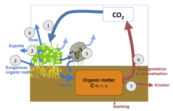
Carbon farming - an answer to the challenges of the XXI century agriculture
Jerzy Kozyra
The presentation is devoted to the topic of carbon farming as one of the answers to the problems of the XXI century agriculture: the biggest of which is climate change that entails droughts, heat waves, and fires. First, dr hab. Jerzy Kozyra presented definitions of carbon farming as a land management practice and as a green business model for farmers, both involving reduction of carbon emissions from agriculture. To understand carbon farming and implement it right, it is important to know how to close the carbon cycle in agriculture and to know the processes carbon is involved in. Carbon farming models can be divided into three categories: action-based, results-based, and hybrid one. An example of a practice-based model is the one included in the eco-schemes introduced in Poland as part of the CAP Strategic Plan for the years 2023-2027. The speaker presented a list of related practices which are eligible for payment under the carbon farming and nutrient management action. Carbon farming practices are also promoted under the Interreg Central Europe programme, for instance, the Carbon Farming CE project, whose objective is to test chosen practices in several European countries and evaluate them, among others, in terms of avoided C/CO2 losses. The project intends also to test farming business models and mainstream the results across Europe.
Key challenges in organic farming
Jarosław Stalenga
The presentation provides detail information about organic farming, which is an environmentally-friendly practice that needs to be further developed. The Commission will boost the development of EU organic farming area with the aim to achieve 25% of total farmland under organic farming by 2030. EU countries have targets for share of organic farmland in 2030 to reach. EU aims to reach in many countries nearly 30% of organic land. Until 2021 most of countries are not even in middle way. The highest share was reported by Austria 26.5%, while Denmark 11.4%, Czech Republic 15.8%, Croatia 8.1%; Finland 14.4%, France 9.6%, Germany 10.8%, Italy 16.7%, Spain 10.8%. Scenarios of organic farmland development in Poland until 2030 were also presented. Realistic scenario -determined on the basis of the trend of changes in the area of organic farmland from 2004 to 2020 shows possibility of growth in 2030 by (1 mln ha) – 6%. While Optimistic scenario -determined on the basis of the trend of changes in the area of organic farmland from 2004 to 2013 shows Share of organic farmland in 2030 (2 mln ha) – 13%. A share of organic farmland in 2022 was (555 000 ha) – 3.8%. The key challenges in organic farming discussed in the presentation: • Yield gap and low competitiveness of organic farming in relation to conventional agriculture • Increasing specialisation of organic agricultural production • Conventionalisation and globalisation of organic market (increasing carbon footprint of BIO products.

Synergy of soil management with bioeconomy
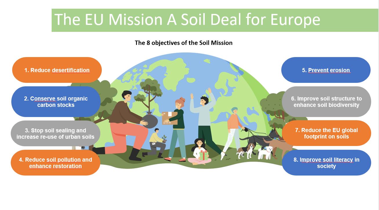
Grzegorz Siebielec
The presentation provides detailed information about the EU Mission “A Soil Deal for Europe”. The main goal of the Mission is to establish 100 living labs and lighthouses to lead the transition towards healthy soils by 2030. Life on Earth depends on healthy soils. Soil is the foundation of our food systems. However, it is estimated that between 60 and 70% of EU soils are unhealthy. The Mission leads the transition towards healthy soils by: • funding an ambitious research and innovation • programmes with a strong social science component • putting in place an effective network of 100 living labs and lighthouses to co create knowledge, test solutions and demonstrate their value in real life conditions • developing a harmonised framework for soil monitoring in Europe • raising people’s awareness on the vital importance of soils. Also featured in the presentation soil – bioeconomy synergies, which includes Circular bioeconomy understood as optimized resource management to close nutrient, energy and biomass circles; innovative technologies for processing and upgrading biological resources to produce the carbon (C)-based products and services demanded by society without fossil carbon or crop residues to produce soil amendments and through pyrolysis, gasification, torrification, fermenatation and co-products (bio-oil, syngas, biogas, bioethanol). It was mentioned that phosphorus recovery plays important role: • About 85-90% of phosphate rock mined in the world is intended for food production (the rest is used for industrial applications such as the production of detergents). • It is estimated that at the current rate of use, the phosphorus resources may be sufficient for 100 – 470 years (FAO, 2008). • This means that the total global phosphorus resources are very limited. Estimates indicate that the increase in phosphorus demand will reach a global peak around 2030. • Therefore, phosphorus has been included in the list of critical raw materials by the European Commission. At the same time, the degree of phosphorus recycling is still low. Part of presentation was dedicated to the drought. The share of farms affected by drought in the most unfavorable growing seasons is extremely large, and the share of municipalities experiencing drought reaches 90% in critical periods. This means that up to 9 million hectares may be affected by drought in some years.